Uncovering the Polar Vortex

Frigid temperatures, icy walkways, frozen waterfalls, and thousands of flight cancellations. Here’s everything you need to know about the phenomena causing it all!
Science or Hype? The Common Misconception
The weather during this time of year is dominating the headline of every newspaper, article and social media post, however there has been some confusion in the media and the general public on what polar vortices are and how they relate to other weather related events. Polar vortices are not unusual, nor are they extreme. In fact they are the prime characteristics of Earth’s climatology.
But the problem is the term “polar vortex” has been misused and explained in literature to explain two different features in atmospheric circulation; one in the troposphere and the other in the stratosphere (don’t let these big names confuse you!) as shown in Figure 1. The issue remains however that not all media outlets explain the difference between these two clearly during extreme weather events.

Figure 1: The atmospheric layers of the Earth
Two Polar Vortices
A polar vortex describes the several different features in the atmosphere usually in the range of mid to high latitude winds circulating from a west to east flow as shown in Figure 2, similar to a clock moving counter clockwise. There are in fact two different polar vortices in the atmosphere: a tropospheric vortex and a stratospheric vortex. The difference between the two are fundamental in understanding how the weather is affecting the Northern part of the globe substantially.
Defining these polar vortices and noting their characteristics could cause confusion to those who haven’t studied meteorology or earth space engineering, but fear not! Part of the reason why I started this blog is because I want to inform you about the complex issues surrounding our daily lives and convert them into a quick and easy read for you.
A stratospheric polar vortex is a low pressure weather system that sits within the Arctic. A tropospheric polar vortex is a feature of mid-latitude weather, its boundary more commonly known as the jet stream. It’s important to know that the vortex in the troposphere is much larger than the vortex in the stratosphere, and that the two are not connected as illustrated in Figure 2. Another distinction is their seasonal fluctuations. While the tropospheric vortex exists all year, the stratospheric vortex exists through fall, winter, and spring. Tropospheric meteorology is studied largely in observing hemispheric circulations and is rarely used to refer to a “polar vortex”. To simplify, I will focus on the stratospheric polar vortex and how it affects tropospheric weather.

Figure 2: Illustration of the stratospheric (blue) and tropospheric (red) polar vortices. Source: Waugh et al. (2017). © American Meteorological Society.
Stratospheric Polar Vortex and Tropospheric Weather
The troposphere is the lowest part of the atmosphere and the closest part to Earth. It’s conditions are often characterized as temperatures decrease with height. The presence of water vapor, clouds, storms, and weather contributes to the significance of the troposphere.
Evidence suggests that vertical mixing between the stratospheric polar vortex has influenced circulation in the troposphere. Think of it like a manual car - the polar vortex acts like a big flywheel - when it weakens, it tends to stay weakened for a while.
When the vortex is strong, the wind going from west to east descend all the way to Earth’s surface. This carries warm air from the ocean to the land. When the jetstream is strong, its fast flowing winds provide a barrier between the cold air in the Arctic and the milder air in the south. When it weakens, the jet stream slows and allows cold Arctic air move southwards into the mid-latitudes as seen in Figure 3. Every winter, the stratospheric polar vortex appears mainly due to the fact that sunlight during this time of year lessens. It begins in the fall when temperatures decrease in the polar regions, strengthen during winter, then eventually breaks off in the Spring.
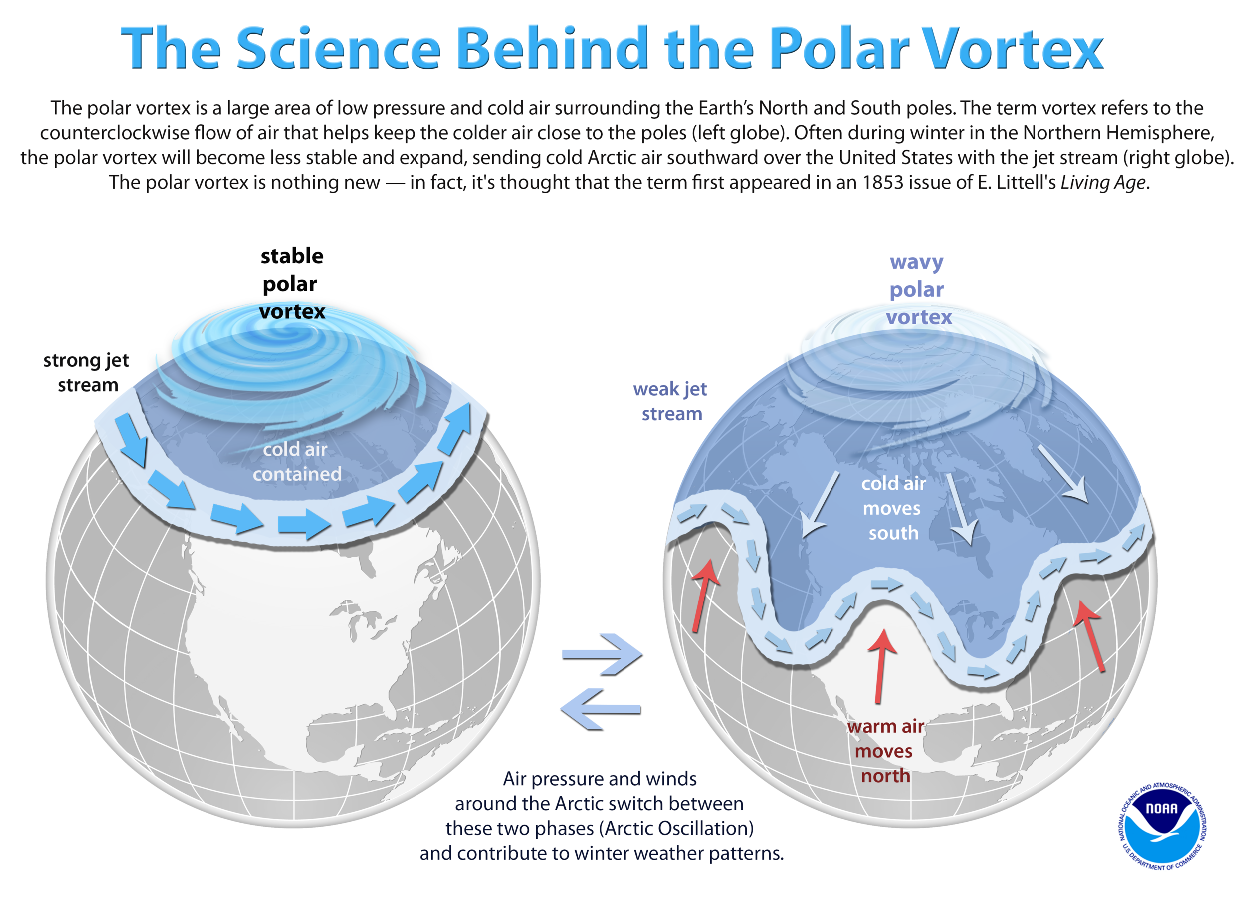
Figure 3: The science behind the polar vortex. Credit: NOAA
Is It A Result of Global Warming?
Yes and no. The Polar Vortex is no stranger to Earth’s climatology. In fact, it’s a natural phenomenon that has occurred for over thousands of years. Ozone depletion due to greenhouse gases such as chlorofluorocarbons (CFCs), however, does present a bigger problem. Stratospheric cooling is mainly caused because of the release of carbon dioxide in the troposphere (global warming). Further cooling of the stratosphere may have an impact on the ozone because a cold stratosphere is necessary for ozone depletion. Releasing more CO2, then, assists in creating an ozone hole formation as well as an increase in Arctic sea loss.
Sources:
Mohanakumar K. “Stratosphere-troposphere interactions”. Springer. 2008.
Waugh, Darryn W. “The Polar Vortex: Meshing and Stripping the Gears of the Atmosphere”. John Hopkins University. 2017.
Waugh, Darryn W, Adam H. Sobel, Lorenzo M. Polvani. “What is the Polar Vortex and How Does it Influence Weather?” American Meteorological Society. 2017.